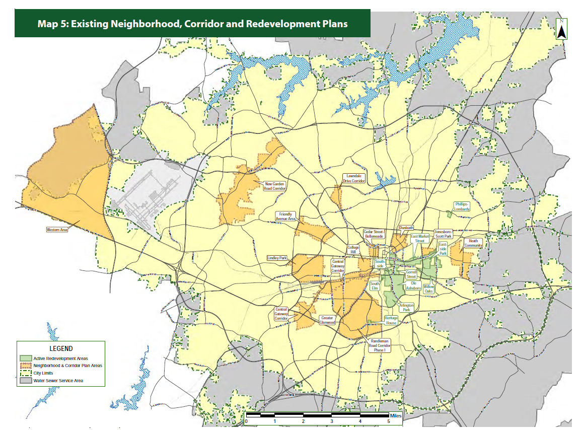
Map 5: Existing Neighborhood, Corridor and Redevelopment Plans
Recommendations of adopted plans in the Existing Neighborhood, Corridor and Redevelopment Plans map are incorporated into the GSO 2040 Comprehensive Plan. Land use designations are based on the categories from Connections 2025 or were developed in consultation with the neighborhood.
Redevelopment Plans
Redevelopment Area designation must meet the requirements of North Carolina statutes and allows the City to use federal funds more effectively. Greensboro has been using these tools for over 50 years.
Greensboro’s Redevelopment activities include:
- Arlington Park Redevelopment Plan
- Eastside Park Redevelopment Plan
- East Market Street Redevelopment Plan
- Gorrell Street Redevelopment Plan
- Heritage House Redevelopment Plan
- Ole Asheboro Redevelopment Plan
- Phillips Lombardy Redevelopment Plan
- South Elm Street Redevelopment Plan
- Southside Area Development Plan
- Willow Oaks Redevelopment Plan
Neighborhood and Corridor Plans
Neighborhood planning activities work closely with other City departments. Unique collaborations provide an opportunity for neighborhoods to manage and guide their community’s future through the development of neighborhood plans.
Area plans conducted by the Planning Department include:
- Cedar Street/Bellemeade Area Plan
- Central Gateway Corridor Plan
- College Hill Neighborhood Plan
- Dunleath Neighborhood Plan
- Friendly Avenue Area Plan
- Greater Glenwood Neighborhood Plan
- Heath Community Strategic Plan
- High Point Road/West Lee Street (Gate City Blvd) Corridor Plan
- Jonesboro Scott Park Neighborhood Plan
- Lawndale Drive Corridor Plan
- Lindley Park Neighborhood Plan
- New Garden Road Strategic Plan
- Randleman Road Corridor Plan
- Western Area Plan

Recommendations, including land use, of the adopted plans shown on the map to the right are incorporated into this Comprehensive Plan.
For more information, see Chapter 10, Map 5 in the GSO2040 Comprehensive Plan.
